Friday, May 31, 2024

Waikiki's Stones of Life ~ Nā Pōhaku Ola Kapaemāhū ā Kapuni


One morning while walking along a stretch of Waikiki some years ago,
I came to an abrupt stop.

I suddenly saw a pile of rocks I had passed dozens of times before:
four huge boulders of basalt,
ironically the first rock I had learned to identify as a small girl.
Once I spotted them, I couldn't imagine how I hadn't seen them.


Google ~ used in a number of places


Granted the basalt boulders are located in a high traffic tourist area
with lots of activity on Kalakaua Avenue, the beach, and in the water,
and I'm guessing I'm not the only person who has overlooked them.
The stones are clustered inside a circular fence on the Diamond Head side
of the Honolulu Police Department's Waikiki Substation on Kūhiō Beach.
They stand near the popular bronze statue of Duke Kahanamoku
and are located just across the street from the Hyatt Regency.

Duke Kahanamoku
Hawaiian Olympic Champion 
and Father of International Surfing 
Honolulu, Hawaii, USA
March 3, 2016

© M. Louise (MacBeath) Barbour/Fundy Blue. All Rights Reserved


When I approached the stones, I saw they were a beautiful vesicular pahoehoe basalt
from the numerous cavities pitting their surfaces, ropy texture,
and the lack of jagged, broken clinker.


The Basalt Stones
with Kalakaua Avenue and the Hyatt Regency in the Background
Honolulu, Hawaii, USA
March 3, 2016
© M. Louise (MacBeath) Barbour/Fundy Blue  All Rights Reserved


Vesicular (Holey) and Pahoehoe (Ropy) Textures
Nā Pōhaku Ola Kapaemāhū ā Kapuni
Honolulu, Hawaii, USA
March  3, 2016
© M. Louise (MacBeath) Barbour/Fundy Blue  All Rights Reserved


The four stones stood on a raised lava stone platform or paepae,
and, when I walked around the fence, I discovered an altar or ahu with flower offerings.
Obviously these were not just any old basalt boulders piled haphazardly near the beach. 

Ahu with Offerings
Nā Pōhaku Ola Kapaemāhū ā Kapuni
Honolulu, Hawai'i, USA
March 3, 2016
© M. Louise (MacBeath) Barbour/Fundy Blue  All Rights Reserved


A Department of Parks and Recreation City and County of Honolulu plaque
revealed the human story behind these sacred boulders, and what a story!

According to orally transmitted legends, the Moʻolelo, 
the Nā Pōhaku Ola Kapaemāhū ā Kapuni, 
or Stones of Life, are the legacy of four powerful māhū or healers,
Kapaemāhū, Kapuni, Kinohi and Kahāloa,
who came from Moa'ulanuiakea, Ra’iātea⁩, some 500 years ago.

They were exceptional individuals, third-gender people with dual male and female spirits.
Sometimes referred to as wizards, the māhū brought the healing arts to Hawaii.

‎⁨Ra’iātea and Tahiti in the Society Islands of French Polynesia


‎⁨Ra’iātea⁩, ⁨French Polynesia⁩
October 21, 2023
© M. Louise (MacBeath) Barbour/Fundy Blue
All Rights Reserved

The four māhū traveled throughout the islands,
becoming famous as they miraculously healed and cured the people.   
Later they settled at a place called Ulukou where the Moana Surfrider now stands.

The time came when the māhū had to return to ‎⁨Ra’iātea.
They asked for two stones to be placed at their Ulukou home
and two more at their favorite bathing place in the sea, 
now known as Kahaloa Beach or Royal Hawaiian Beach.
Four huge stones were quarried from the basaltic rock at Kaimukī,
chosen by the māhū because they rang like a bell when struck.

On Pō Kāne (the Night of Kane) thousands moved the rocks
from the Kaimukī quarry, a distance of almost two miles.
After a full cycle of the moon filled with fasting, prayers, and incantations,
each māhū gave his-her name and mana or spiritual power to one of the four stones.
The original account indicates that a young chieftess was sacrificed
and placed beneath the stone of the head mākū, Kapaemāhū. 
Then the four vanished.   

Hidden in Plain Sight
The Healing Stones of Waikiki
Honolulu, Hawai'i, USA
© M. Louise (MacBeath) Barbour/Fundy Blue
All Rights Reserved


Stones of Life


These culturally significant stones faded from general memory as well.
In 1907, the stones were rediscovered on the site of Princess Kaʻiulani's home.

In 1910, Governor Archibald Cleghorn, father of Princess Kaʻiulani,
stipulated that the stones stay on the property and the property be given to the city.

Governor Archibald Cleghorn 

In 1941, the city leased the property to build a bowling alley,
and the sacred stones were used in the building's foundation.
Next, 1958, the stones were identified and repaired
when the bowling alley was demolished.
Then, in 1963, the stones were moved to Kūhiō Beach.
Finally, in 1980 the stones were moved 50 feet mauka, toward the mountains. 

Nā Pōhaku Ola Kapaemāhū ā Kapuni ~ Stones of Life
Kūhiō Beach, Honolulu, Hawai'i, USA
March 3, 2016
© M. Louise (MacBeath) Barbour/Fundy Blue  All Rights Reserved


During the 1970s, Hawaiians experienced a cultural renaissance
and growing pride in their hula, music, language, and traditional sea voyages.

Celebrating Hawaiian Culture on Prince Kūhiō's Birthday
Hyatt Regency, Waikiki 
Honolulu, Hawai'i, USA
March 26, 2014
© M. Louise (MacBeath) Barbour/Fundy Blue  All Rights Reserved


When the stones' cultural significance was fully understood,
a group of people worked to create a wahi pana (sacred place) for the healing stones.

The four stones were placed on the platform (paepae) and protected with the altar (ahu).

Healing plants were planted at the site:  bamboo (ohe), wild tobacco (makahala),
Hawaiian cotton (mao), and beach naupaka (naupaka kahakai). 

During the final ceremonies, a Tahitian delegation from ‎⁨Ra’iātea
blessed the sacred stones and gave a small stone from Tahiti as an offering.

The Tahitian Stone, Ta‘ahu ea, as an Offering, ho‘okupu  
Honolulu, Hawai'i, USA
March 3, 2016
© M. Louise (MacBeath) Barbour/Fundy Blue  All Rights Reserved


On October 24, 2023 a new plaque for the stones was dedicated.
After more than a century of suppression, the true nature of the mākū was acknowledged.
Neither male or female, the mākū were traditionally considered a third gender
and revered by Polynesian, Hawaiian, and other cultures throughout the Pacific.
Furthermore, the four healers' duality of spirit enhanced their healing powers,
which included laying of the hands and the use of medicinal plants.

Those of you who know me and my blog know I love to travel.
Perhaps the thing I appreciate most about traveling
is learning about different people and cultures.
My Western and Christian backgrounds have shaped my thinking,
and it's important for me to question my beliefs and challenge them with new perspectives.
The more I experience and learn, the more I believe
that gender extends beyond male and female.


Have a great weekend! 


Till next time ~
Fundy Blue.

‎⁨Waimanalo Beach Park⁩, ⁨Oʻahu⁩⁩,
March 2, 2024
© M. Louise (MacBeath) Barbour/Fundy Blue
All Rights Reserved


Note:  I did a lot of research on the healing stones.  There is conflicting, incomplete, and inaccurate information online.  I've used the most accurate information I could find, and if there is any wrong information in my post, the fault is mine.  

Māhū:  "mahu – a Polynesian term for third gender individuals who are neither male nor female but a mixture of both in mind, heart, and spirit." 


Indigenous Peoples Literature Mythologies of French Polynesia/Tahiti

Ka'iwakīloumoku Pacific Indigenous Institute

Wikimedia:  Kapaemahu (The Stones of Life) in Waikīkī.

Location of Moa'ulanuiakea.  Some sources say Moa'ulanuiakea is in Tahiti, and I couldn't find it on a map.  Tahiti may be a general reference for the islands or a reference for the island of Tahiti.

Text of Older Plaque

Image of New Plaque

Friday, May 24, 2024

A Mighty Fortress

In my March 22, 2024 post I wrote about my family's love of history
and about visiting two powerful military sites during the previous twelve months.
I saw the sites as historical bookends,
linking the beginning and end of defensive coastal fortifications and artilleries.
I didn't name the strategic sites, but indicated that I would write about them shortly.

My Dad, the History Major, at Acadia
Acadia University, Wolfville, Nova Scotia, Canada 
Circa 1947
© M. Louise (MacBeath) Barbour/Fundy Blue
All Rights Reserved

When my original post was published it was flagged 
with a warning for containing sensitive material.
To say I was shocked is an understatement.
I went over and over the post, but I couldn't figure out what was objectionable.

I tried to contact Google to find out what happened,
but I hit a wall and couldn't access any help.  I gave up.

My Mom, Who Encouraged my Love of  Reading About Everything
Acadia University, Wolfville, Nova Scotia, Canada 
1947
© M. Louise (MacBeath) Barbour/Fundy Blue  All Rights Reserved

So, I'm going to go back to the topic, and I will see what happens.
Fingers crossed, for sure!  

In both instances world powers were struggling for control of a strategic site 
that was a gateway to resources, trade, commerce, and empire.

A Strategic Site Overlooking San Juan Bay
San Juan, Puerto Rico 
April 15, 2023
© M. Louise (MacBeath) Barbour/Fundy Blue  All Rights Reserved

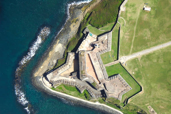
Castillo San Felipe del Morro, or El Morro as it is commonly referred to, is the first site.
What began in 1539 as a tower and three cannons
on a promontory overlooking the entrance to San Juan Bay
became over the next 250 years a mighty six-level fortress
incorporating the highest military standards and technology of its time.

El Morro from the Air
San Juan, Puerto Rico 


El Morro is considered the oldest Spanish fort in the New World.
Spain held El Morro for 359 years until the US gained
control of it in 1898 during the Spanish American War.
It remained an active US military installation during the first and second world wars.
The US Army retired El Morro in 1961 and turned it over to the National Park Service.
The United Nations declared the fortress and walled city of Old San Juan 
UNESCO World Heritage Sites in 1983.

Three UNESCO sites protecting San Juan and Puerto Rico:
Fortín San Juan de la Cruz (El Cañuelo - "Small Channel")
Castillo San Felipe del Morro
Castillo de San Cristóbal
April 14, 2023
© M. Louise (MacBeath) Barbour/Fundy Blue. All Rights Reserved


Overlooking the Entrance to San Juan Bay and Fortín San Juan de la Cruz from El Morro
Crossfire between El Morro and Fortín San Juan de la Cruz 
protected San Juan Bay and the interior of Puerto Rico from invaders.
April 15, 2023
© M. Louise (MacBeath) Barbour/Fundy Blue. All Rights Reserved


It's one thing to look at the fortress in photographs, drawings, and maps.
It's quite another to wander through the Field of Fire where so many died,
and to touch the walls and walk the floors of the fortress.
You can feel the history and emotions of centuries 
emanating from the grounds and stones surrounding you.    

Field of Fire, or Esplanade, at Castillo San Felipe del Morro
San Juan, Puerto, USA
April 15, 2023
© M. Louise (MacBeath) Barbour/Fundy Blue  All Rights Reserved


Historically an esplanade was a large, open area outside a fortress.
It provided clear "fields of fire" for the fortress's guns.
Today the Esplanade is a place where locals come to relax, picnic, and fly kites.

Locals Enjoying a Beautiful Morning on the Esplanade
San Juan, Puerto, USA
April 15, 2023
© M. Louise (MacBeath) Barbour/Fundy Blue. All Rights Reserved


The massive fortress was designed to repel attacks by sea,
and over the centuries it successfully blocked every naval assault,
including three British attacks in 1595, 1598, and 1797 and one Dutch in 1625.
During the Spanish-Cuban-American War of 1898, El Morro saw action for the last time.
After the U.S. occupied Puerto Rico in 1898, 
control of all the Spanish-era fortresses passed to the U.S. Army.

To enter El Morro today, you cross over a concrete bridge above the dry moat.
In colonial times the bridge was a drawbridge protecting the eastern side of the fortress.
The dry moat had two purposes, to protect the base of the fort from enemy cannon fire
and to force enemy soldiers to descend before before trying to scale the fortress walls.

The Concrete Bridge and Dry Moat at El Morro


The Entrance to El Morro
April 15, 2023
© M. Louise (MacBeath) Barbour/Fundy Blue  All Rights Reserved


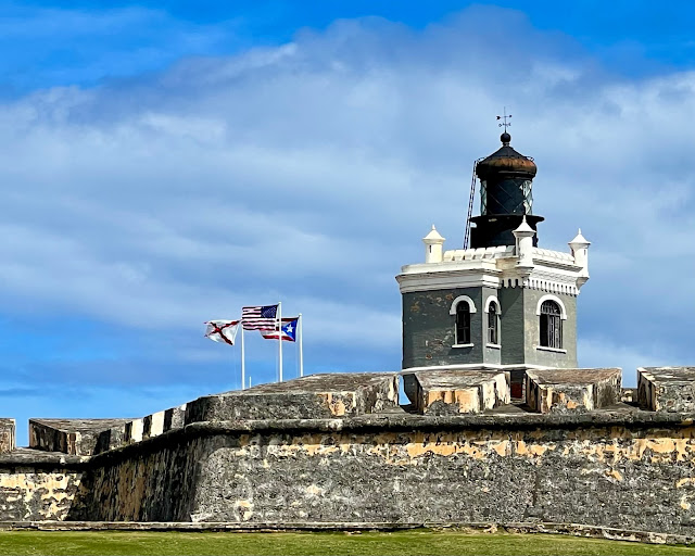
To the right of the entrance is the El Morro Lighthouse.
Puerto Rico's first lighthouse was built at El Morro in 1846.
The current lighthouse was built by the U.S. Coast Guard in 1908.
It is only 51 feet high, but it sits on the sixth level of El Morro 
giving it another 140 feet in height.

The El Morro Lighthouse Located on the Ochoa Bastion
April 15, 2023
© M. Louise (MacBeath) Barbour/Fundy Blue  All Rights Reserved


When you pass through the entrance, you enter The Plaza de Armas
or Main Plaza on the Fifth Level of El Morro.  
Today the main plaza looks very much like it did when it was completed around 1780.
Here troops drilled and assembled for formal occasions.
Around the plaza are arched casements, large vaulted rooms that contained 
a kitchen, chapel, storage areas, officers’ quarters, and barracks for enlisted men.


The Plaza de Armas or Main Plaza of El Morro
April 15, 2023
© M. Louise (MacBeath) Barbour/Fundy Blue. All Rights Reserved


The Plaza de Armas or Main Plaza of El Morro
Information Sign
April 15, 2023
© M. Louise (MacBeath) Barbour/Fundy Blue  All Rights Reserved


Capilla de Nuestra Señora de los Navegantes
(Chapel of Our Lady of the Navigators)
This small chapel occupies one of the casements in the main plaza of El Morro.
The arch in a casement provided strength to support gun decks above it
and protection from the concussion of exploding shells.
April 15, 2023
© M. Louise (MacBeath) Barbour/Fundy Blue. All Rights Reserved


The Plaza de Armas or Main Plaza on the Fifth Level of El Morro
Here you can see the wellhead where soldiers drew water from three large cisterns under the plaza.
April 15, 2023
© M. Louise (MacBeath) Barbour/Fundy Blue  All Rights Reserved


By the early 1500s, Spain had already conquered what are now Mexico and Peru.
These lands had abundant gold, other precious metals, and gems
which the Spanish plundered and mined.
They sent these treasures back to Spain on galleons.

A Spanish Galleon


In order to protect these ships from the English, French and Dutch,
Spain began fortifying important ports along the sea routes.
Because San Juan was the first port encountered by ships entering the Caribbean,
the Spanish Crown recognized that it needed to be fortified.

Initially El Morro consisted of a masonry tower and a water battery with three cannons.
The gunners quickly discovered that the noise and smoke
from firing cannons inside the tower was too much to bear.
Thus began a learning process that spanned centuries. 
After attacks and discoveries of weaknesses, 
El Morro would expand and improve its defensives.

King Philip II ordered the addition of a hornwork and two half-bastions connected by a curtain wall to protect the landward approach to the original tower,
as well as a moat to give more height to the walls and a drawbridge.
The work was completed in 1595.

El Morro in 1891
The curtain, or defensive wall, joins two half bastions on the landward approach to the original tower.
The tower is the circle in the lower left.
Today the bastions are known as the Ochoa Bastion (upper left) and the Austria Bastion (upper right).
They form the sixth level of the fortress that rises over visitors as they approach the entrance to El Morro.
wikipedia (image modified by me ~ see site for license) 


Here you can see the "horns" of the half bastions protecting the entrance to El Morro:
also the dry moat, the cement bridge spanning the moat,
and the bastions and curtain wall of the sixth level (gray)
and the main plaza of the fifth level (orange).


Terry Explores the Bacteria del Carmen on the Fifth Level of El Morro
April 15, 2023
© M. Louise (MacBeath) Barbour/Fundy Blue. All Rights Reserved


The El Morro Lighthouse on Level Six of El Morro
April 15, 2023
© M. Louise (MacBeath) Barbour/Fundy Blue  All Rights Reserved


The Three Flags Flown at El Morro Today
The Cross of Burgundy ~ The Old Spanish Military Flag Which Was Flown at El Morro from 1539-1785
The United States Flag and the Puerto Rican Flag
April 15, 2023
© M. Louise (MacBeath) Barbour/Fundy Blue  All Rights Reserved


Terry Enjoys The View of Old San Juan
from Level Six of El Morro
April 15, 2023
© M. Louise (MacBeath) Barbour/Fundy Blue  All Rights Reserved


Cannons on the Main Firing Battery
Level Four of El Morro
April 15, 2023
© M. Louise (MacBeath) Barbour/Fundy Blue  All Rights Reserved


The Spanish completed El Morro in 1790.  
Their latest improvements to the fortress included 
3 cisterns under the main plaza that held 216,000 gallons of water
and walls strengthened to 18-40 feet thick.
The main Santa Barbara Battery had 37 cannons 
backed by casement guns at higher and lower levels.
    

Terry Emerges from a Garita or Sentry Box
Level Four of El Morro
April 15, 2023
© M. Louise (MacBeath) Barbour/Fundy Blue  All Rights Reserved


The Main Artillery Ramp and Stairs at El Morro
Leading to the Main Battery on Level 4
Soldiers raised and lowered 5-ton cannons on this ramp. 
April 15, 2023
© M. Louise (MacBeath) Barbour/Fundy Blue  All Rights Reserved


The Main Artillery Ramp, Guard House, and Walls
Main Battery on Level 4
April 15, 2023
© M. Louise (MacBeath) Barbour/Fundy Blue  All Rights Reserved


Terry's and my visit to El Morro was far too short.  
We scrambled to see what we could in less than an hour.
I would love to return to this formidable fortress and spend more time here.

The second strategic site lies on a different side of the Americas and in another ocean.
World War II demonstrated that the time for defensive coastal fortifications 
and artilleries had passed.  They were no longer effective in modern warfare.


For Rain:  Vincent Van Gogh ~ 
I know I have a photo of Vincent van Gogh's Sunflowers from the National Gallery in London, but I can't find it.
  
Sunflowers by Vincent van Gogh 1888
National Gallery
London, United Kingdom


Sunflowers
Victoria, British Columbia, Canada
September 12, 2017
© M. Louise (MacBeath) Barbour/Fundy Blue  All Rights Reserved

Opps!  These Are Coneflowers!


Sunflower and Bee
Butchart Gardens
Brentwood Bay, British Columbia, Canada
September 12, 2017
© M. Louise (MacBeath) Barbour/Fundy Blue  All Rights Reserved


For Tom:  Aloha ~ A Hawaiian Sunflower! 

Yellow Hibiscus
Honolulu, O'ahu, Hawai'i
January 27,  2024
© M. Louise (MacBeath) Barbour/Fundy Blue. All Rights Reserved


For Nicole:  Curiosity ~ 
I could find Terry in the National Gallery, but not Vincent.


Terry Views a Lion-Headed Dagger
India, Mughal Dynasty 1650-1700
The National Gallery, London, United Kingdom
September 3, 2015
© M. Louise (MacBeath) Barbour/Fundy Blue. All Rights Reserved


Have a great weekend! 


Till next time ~
Fundy Blue

My next post will be 
Wednesday, May 31st. 🤞 


On the Bay of Fundy
© M. Louise (MacBeath) Barbour/Fundy Blue
All Rights Reserved